

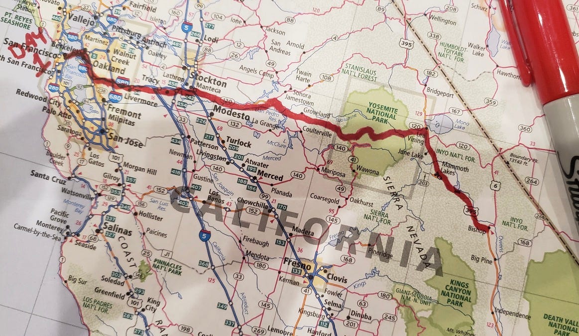
Day 1: San Francisco, CA to Bishop, CA
Day 1: San Francisco, CA to Bishop, CA
A vast scale model, Reberites, invasive grasses, Spanish for butter, haunted hotel, Estanislao, odd slender columns, the Camel Corps

There are two San Francisco Bays - a bay in the Bay, and one in Sausalito. The Bay in Sausalito is a vast scale model, over one-hundred thousand square feet (two football fields), molded out of concrete and filled with flowing water; the tide goes out and comes back in every fifteen minutes or so. It was built by the US Army Corps of Engineers in 1957 to settle an argument.
The argument stemmed from a man named John Reber. Reber migrated to California in 1907 and established himself as a local playwright and theatre director. By 1929 he’d determined that his experience in stage management granted him special insights into geography, hydrology, and urban planning - “What is master planning but stage managing an area?” he asked, a question that it is hard to know how to answer. Applying these insights he determined that the Bay was “a geological mistake,” and that it should be dammed up and turned into a lake. This sounds impractical, but Reber’s idea was popular enough that there came to be such a thing as Reberites (Herbert Hoover was one). Debate over Reberism dragged on for decades until the 1950s; finally the Army was called in to sort things out. Tests of the Reber plan using their model were completed in 1960; the plan was found to be “infeasible by any frame of reference.” John Reber died the same year. The model still stands, in a hanger in Sausalito.

We will cross the Bay in the bay, across the Golden Gate Bridge, perhaps cupped by thick morning fog. Arriving on the eastern shore we go south to Castro Valley, then head east again on the I-580 though a landscape of semi-picturesque suburbia, past Dublin (the seventh best place in America to live per Money magazine), Asco, Livermore, and Ulmar.
Between Ulmar and Tracy is a stretch of empty rolling hills. During the dry season the hills shine bright gold in the sun, covered with the dry reflective stalks of invasive grasses: wild oats, fescue, cheatgrass, filagree. Cresting the hills are the three-bladed turbines of the Altamont Pass wind farm.
Across the pass is the town of Tracy, where Kerouac stopped while hitching south from Oakland to Bakersfield - “Tracy is a railroad town; brakemen eat surly meals in diners by the track.” After leaving Tracy he heads south as evening sets:
The sun goes down long and red. All the magic names of the valley unrolled—Manteca, Madera, all the rest. Soon it got dusk, a grapy dusk, a purple dusk over tangerine groves and long melon fields; the sun the color of pressed grapes, slashed with burgundy red, the fields the color of love and Spanish mysteries. I stuck my head out the window and took deep breaths of the fragrant air. It was the most beautiful of all moments.
Manteca is Spanish for butter, Madera is Spanish for wood - I like to imagine a convoluted alternate history that results in small towns scattered across the Andalusian Plain surfacing the hidden euphony of commonplace English: Sixteen, Rubber Ball, Eyetooth, Soapsuds.
East of Tracy is Banta, named for Banta’s White House hotel, which is haunted by three ghosts - a mother, her daughter, and a hostler whose spirit occasionally tidies the coins in the cash register. We are on the CA-120 now, following the banks of the Stanislaus River, formerly the Río de los Laquisimes. Stanislaus is a bastardization of Estanislao, a Yokut rebel who raided the Spanish and Mexican settlements in the area, and who was one of the inspirations for the character of Zorro. Leaving the river we jag north around the Red Hills, cross Woods Creek, and take a long climb toward Yosemite, the road now lined with pine and fir trees, entering the park at the Big Oak Flat gate.
Yosemite is an awesome place to be just passing through, but we pass through it, turn south at Mono Lake on US-395, and drive into the Inyo National Forest, past Crowley Lake (whose abutting cliffs are supported by odd, slender columns, of origins once mysterious but now explained by science) and then out again and across the Owens Valley desert - home to the Owens pupfish, a small shimmery fish so endangered that at one point its entire population was contained in two buckets.
In the evening we arrive at Bishop, a small city in the Eastern Sierras, westerny, touristy (lots of signage), a place for outdoorsy people. It holds an annual Mule Day, which features “the world’s largest non-motorized parade.” Its namesake is Samuel Addison Bishop, a rancher and banker. He was a lieutenant in the Mariposa War, a brutal land grab perpetrated by forty-niners against the Ahwahneeczhees and Chowchilla. Later in life he helped found the San Jose streetcar system.
But the most interesting thing about Samuel Addison Bishop is that he lead the only military action involving camels to ever take place on American soil. In 1856 the US government purchased 33 camels: “two Bactrian (two-humped), nineteen dromedaries (one-humped), nineteen Arabian, one Tunis burden, one Arabian calf, and one Tuili or booghdee camels.” The idea was that these camels would be well-adapted to conditions in the American Southwest, where they could be used as pack animals. Numerous tests were carried out with the camels, including an attempt to use them in a sort of Camel Express postal system (sadly the camels involved died of exhaustion), and at some point in their wanderings the camels were housed at Bishop’s ranch. Bishop put the camels to work hauling freight. During one such trip his men came into conflict with a group of Mohave; they charged on the camels, the Mohave fled. Soon after the Army reclaimed their camels.

With the coming of the Civil War the camel operation was sidelined, then forgotten. The camels were sold off. As Vince Hawkins writes in his excellent article on the topic:
The camels ended up in circuses, giving rides to children, running in “camel races,” living on private ranches, or working as pack animals for miners and prospectors. They became a familiar sight in California, the Southwest, Northwest, and even as far away as British Columbia, their strange appearance often drawing crowds of curious people… Eventually, when the curiosity wore off or their new owners simply did not want or need them anymore, many of the camels were turned loose in the wild to fend for themselves. They were seen for many years afterward, wandering the deserts and plains of the Southwest. The last of the original Army camels, Topsy, was reported to have died in April 1934, at Griffith Park, Los Angeles, at the age of eighty, but accounts of camel sightings continued for decades.
Having arrived in Bishop we will have ascended between 3,216 to 4,098 feet during the day, depending on where in San Francisco we set out from.
Sources:
The Man Who Helped Save the Bay by Trying to Destroy It, by Charles Wollenberg
Grassland Heritage, by David Amme
The U.S. Army’s “Camel Corps” Experiment, by Vince Hawkins
On the Road, by Jack Kerouac